

Trailside VitalsExplore
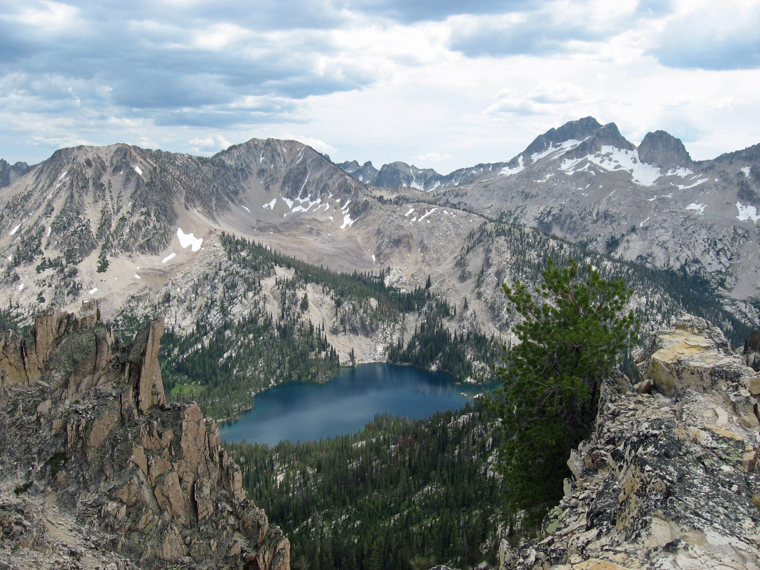
Toxaway Lake lies below rugged Sawtooth peaks, seen between rocky outcrops from a high mountain pass.
Toxaway Lake – Fredlyfish4; responsive crops/resizing by Trailside Vitals. / Creative Commons Attribution-ShareAlike 4.0 International (CC BY-SA 4.0)

Alice–Toxaway Loop

Location: Idaho — Sawtooth Wilderness

Camp beneath jagged Sawtooth peaks and cross Snowyside Pass between alpine lakes.

Essential facts

Challenge
Hard
Planning duration
2–3 days
Route distance
18.6 mi GPX-derived horizontal estimate (not official). Variant: Alice–Toxaway Loop | Clockwise, Alice Lake first | Planning.

Overview

Backpack into the Alice–Toxaway drainage, cross Snowyside Pass and return through a different chain of Sawtooth lakes. Forested approaches give way to granite walls, high lakes and an alpine crossing. The interpretive association describes it as one of the area's relatively few true loops and allows travel in either direction.

This is a good fit for backpackers ready to combine overnight self-sufficiency with an alpine pass, not an automatically easy first trip. The difference between two days and three days matters: a two-day plan concentrates the walking and pack burden, while an extra night may spread effort only if suitable legal camping fits the group. A shorter three-day variant does not establish a verified daily ascent profile.

Suggested highlights are the linked lake basins, a true circuit from one access area and the opportunity to spend an evening away from the roadside. Lakeshore camps may be shared. Check swimming conditions, and treat flowers, goat sightings and sunsets as possibilities rather than promises. This is a popular route with fragile habitat and limited parking, not a guaranteed quiet escape.
At a glance

Cost & booking summary
Required wilderness trail permit is free; eight or more need free advance large-group authorization. This does not reserve a campsite. Developed Pettit camping, transport, food and gear are separate; no full-trip quote is verified.

See dated prices & planning options

Prices, access, entry and operating details below are dated research, not live availability or a booking guarantee.

Before you book or set out

  • Permit and group: Complete the trailhead permit. Eight or more need advance group authorization; maximum twelve May-November and twenty December-April under the cited order, unless changed.
  • Camping: No reserved-pitch system is established. Follow signs and legal established-site guidance, retain a backup and do not camp contrary to posted restrictions.
  • Restrictions: No campfires on this loop; old fire rings do not grant permission. Follow temporary stove/fire restrictions and the seasonal dog-leash rule.
  • Conditions: Snowyside can hold snow late into summer and early crossings can be high. Obtain current conditions and food-storage rules, treat water and start with treated supply; gateway potable water is not advertised.
Route alternatives, season & research details

Route variants and season

Both directions are possible. Route selection should consider the location of legal established camps, the group's loaded-climb capacity, the day's weather and stream/snow conditions. An Alice Lake out-and-back is a separate alternative, not completion of the full Alice–Toxaway circuit. Additional lake or summit spurs mentioned by the Forest Service are not included by default.

The interpretive association specifically warns that Snowyside Pass retains snow late into summer and early-summer creek crossings can be high. No guaranteed opening date, bridge timetable or snow-free 2027 season was verified. Select dates from current ranger advice and actual conditions. A normal-season backpack should be postponed or redesigned if steep snow demands skills the party does not possess; poles and a purchased traction device alone are not a safety qualification.

The cited occupancy order is effective February 20, 2025–February 20, 2030 unless rescinded. That is a legal-order validity window, not a trail operating season or proof of future access. Recheck fire, flood, trail and food-storage notices shortly before travel.

Route & getting there

Arrivals, transport and overnight choices

The official campground directions run south from Stanley on Highway 75 and then along Forest Road 208 toward Pettit Lake. Tin Cup trail access is at the campground's north end. Treat the hiker trailhead, campground and day-use area as distinct facilities. The interpretive association warns of limited hiker parking, requires designated spaces and mentions overflow at Tin Cup Horse Trailhead; confirm that option remains allowed rather than parking on vegetation or the road.

This loop normally returns to the same trailhead, so it needs no transfer between trailheads. Arrange your own transport to Pettit Lake; no scheduled Stanley/Pettit service, fare or late pickup is verified. You do not need the Redfish Lake boat for this start.

Pettit Lake Campground lists nine single and three double sites, all first-come, first-served, and vault toilets. Crucially, the current page says potable water is not available, as does the hiker trailhead page. Bring sufficient arrival water and a treatment plan; do not repeat older assumptions of a campground tap. The campground is a separate possible staging night, not part of a wilderness permit and not a reserved vacancy.

Redfish Lake Lodge offers cabins/rooms as an optional regional pre/post-trip alternative, away from the actual Pettit Lake trailhead. Dates, rates, vehicle logistics, baggage storage and opening season still need direct confirmation. No room is included.

Route map & GPX

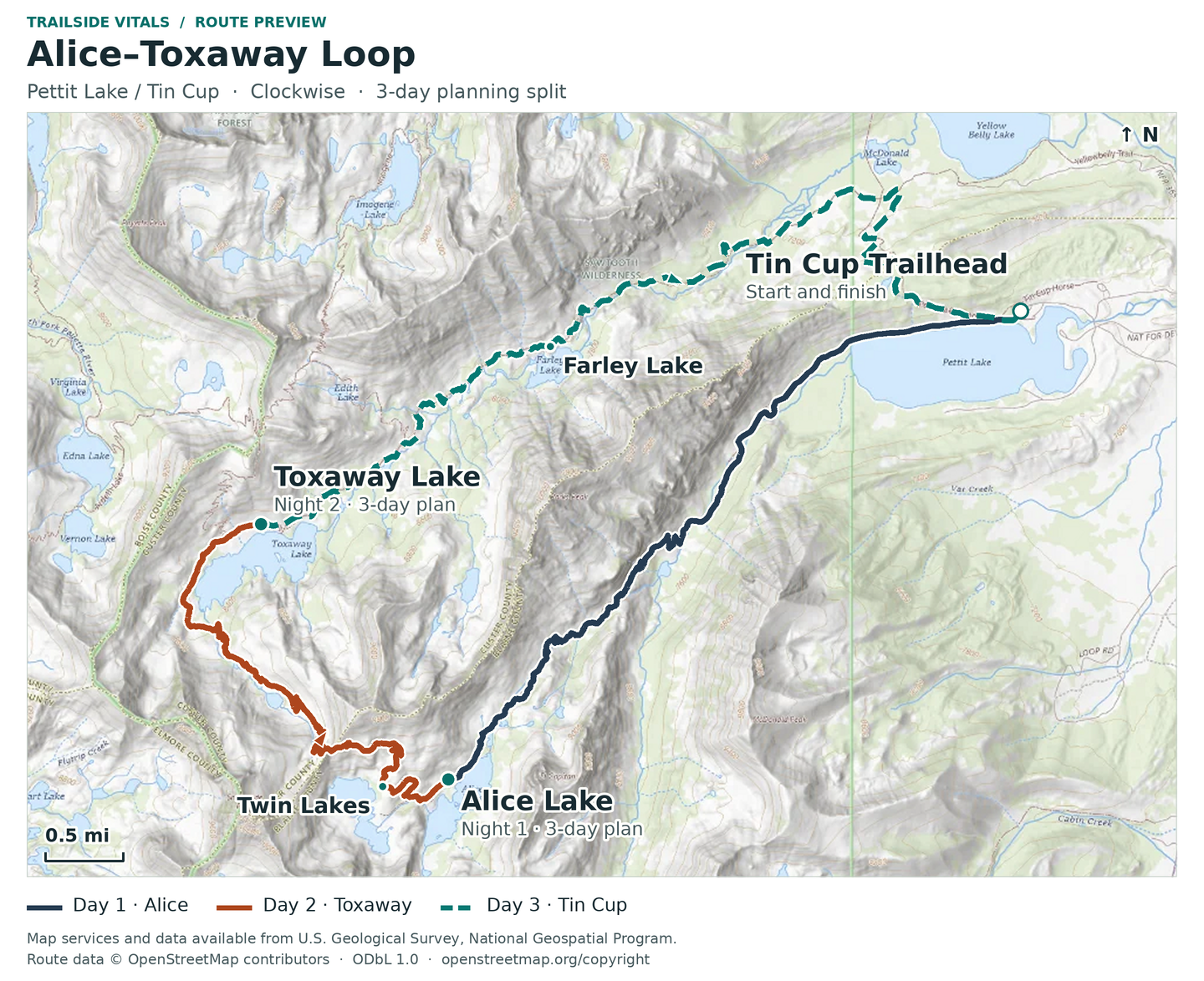
Alice–Toxaway Loop | Clockwise, Alice Lake first | Planning

Overnight markers derive from the supplied daily track endpoints and may indicate a trail or camping-area approach, not a tent pad.

Plan and day selection update the route, markers, notes, and download together.

Complete-route map preview for Alice–Toxaway Loop
Complete-route preview

Map loading. GPX downloads are available below.

Download complete-route GPX

Map data © OpenStreetMap contributors. Open Database License (ODbL) 1.0.

Route sources, alignment, access and conditions notes

Dated access and conditions note (November 10, 2026)

The normal loop crosses Pettit Creek several times. Two separately mapped high-water routes occur in that drainage. This pack follows the standard mapped trail. Use current ranger advice and on-site signs for conditions and crossing choices.
Snowyside Divide can retain steep snow late into summer. Check the current trail, weather and creek conditions for the hike date. These files represent the normal backpacking-season alignment.
The current Forest Service alerts page was checked on 2026-11-10. The Grandjean debris-flow closure concerns a different trailhead and area. Current alerts reviewed did not identify an Alice–Toxaway trail realignment. Forest orders and posted restrictions still apply.
Complete the free trailhead permit. Campfires are prohibited on this loop. The current wilderness order requires compliance with posted camping signs.
The archived 2024 trail-condition table was used for trail identity and general loop distance. Its dated condition reports do not establish current access.

Tin Cup Hiker Trailhead, Pettit Lake – Trailhead

Open location on OpenStreetMap (external map)

Reservations & costs

Trailhead and large-group permits

Complete the free trail permit; eight or more need advance group authorization and seasonal maximums still apply.

More about Trailhead and large-group permits

The Forest Service requires a free wilderness trail permit available at the trailhead. For eight or more people, arrange a large-group permit in advance through Sawtooth NRA, telephone 208-727-5000; it is also free. That special-permit threshold is not the maximum group size: the current occupancy order prohibits groups over twelve May 1–November 30 and over twenty December 1–April 30. A small independent party avoids unnecessary group pressure but still needs its permit.

Legal camps, not reserved pitches

No advance campsite booking system is verified. Use legal established sites, follow posted restrictions and keep a backup.

More about Legal camps, not reserved pitches

No advance per-camp quota or numbered campsite reservation mechanism was verified for this loop. Keep a backup campsite in mind. Follow posted camping signs, established durable sites and current district instructions; allow for a backup location. The order prohibits camping contrary to signs and shortcutting switchbacks.

No campfires on this loop

Existing fire rings do not grant permission. Stove, dog and temporary restriction rules remain applicable.

More about No campfires on this loop

No campfires on this loop. The trailhead page states this directly; the order prohibits fires in the Pettit and Yellow Belly Lake Creek drainages, and the interpretive association reinforces that existing rock fire rings are not permission. Plan portable-stove cooking and comply with any stricter temporary fire restriction. The order requires dogs on trails to be on a leash no longer than fifteen feet July 1–Labor Day; that does not waive other wildlife or access rules.

Wilderness trail permit

Free required trail permit does not reserve a campsite.

Basis/year
$0, per required permit
Inclusions/exclusions
Self-issued at trailhead; not a reserved camp.

Large-group permit

Free advance large-group authorization still has group limits.

Basis/year
$0; advance authorization for eight or more
Inclusions/exclusions
Group maximum still applies.

Pettit developed campsite

Developed camping is a separate first-come fee site without potable water.

Basis/year
Fee site; exact current amount not verified
Inclusions/exclusions
Separate first-come staging option; no potable water.

Road transport, lodge, gear and food

Road transport and lodge stays need separate quotes.

Basis/year
Live quote required
Inclusions/exclusions
No shuttle fare, room rate, package or discount is confirmed.

Price date & basis

USD; checked 2026-10-30. No full-trip quotation.

Preparation

Preparation, equipment and water

Plan water treatment, dependable carrying capacity and a ranger-confirmed source assessment for the selected camps and pass crossing. Lakes on a map do not establish safe untreated drinking water, access from every camp or late-season stream flow. Start with treated water because neither gateway facility currently advertises potable supply.

The interpretive association advises a proper bear hang or bear-resistant container and strongly recommends packing out human waste with WAG bags to protect thin alpine soils and water. That advice is not independent verification of every current food-storage order. Ask the district for the rule covering the actual travel dates and select a compliant system. The occupancy order prohibits depositing human waste within 100 feet of water or campsites and requires burial outside those areas; do not misquote this as a universal camping setback.

Carry shelter, layered insulation, rain protection, a stove, offline navigation and a communication/retreat plan. Prepare for stream crossings without treating a water depth or crossing time as guaranteed. Avoid cutting switchbacks or widening camp areas, and pack out all trash, including waste bags.

Sources & references

General adventure information

Article research and source-date qualifications

Planning options sources

Planning options use the general references above.