

Trailside VitalsExplore
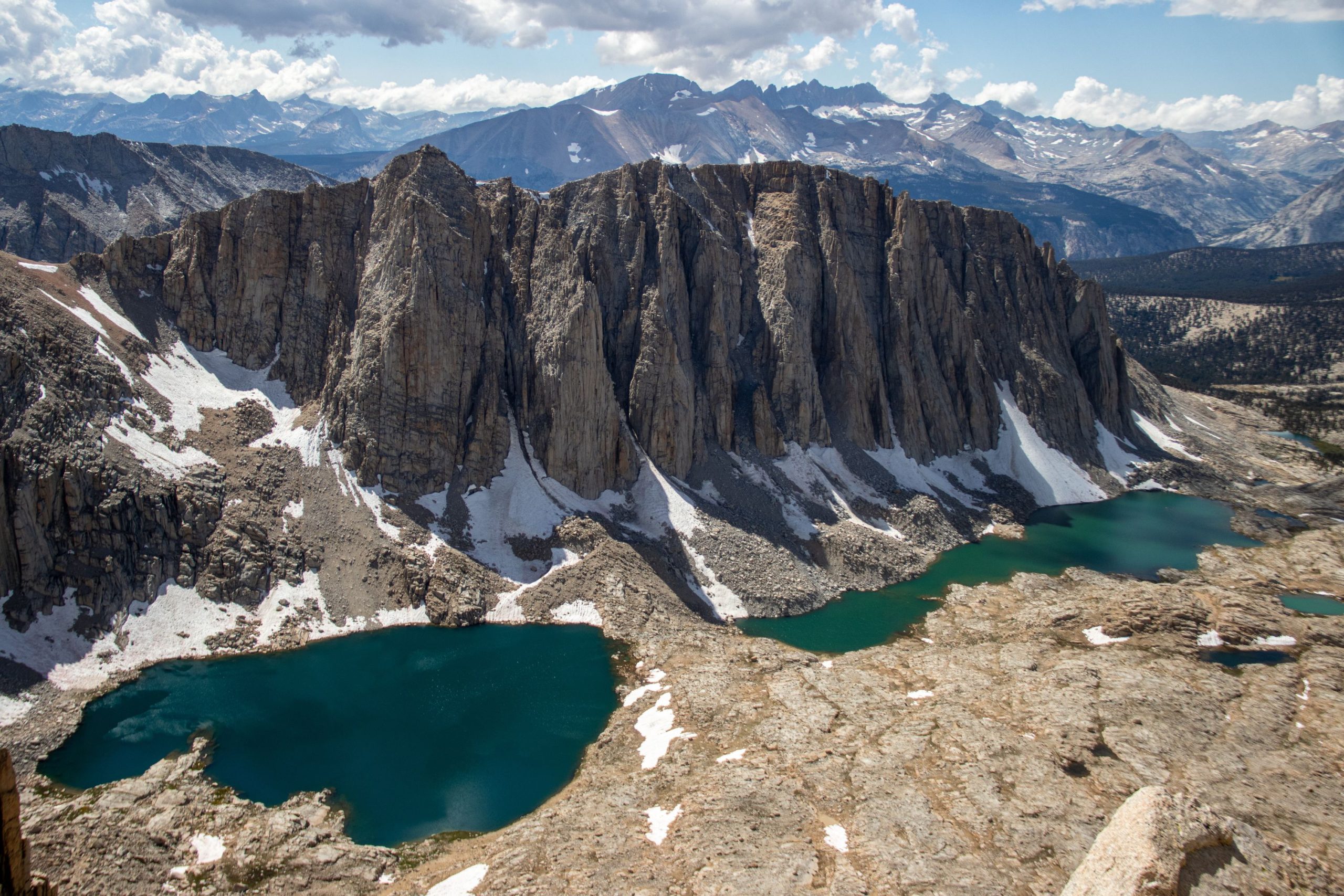
Two turquoise Hitchcock Lakes sit below dramatic granite cliffs amid the expansive Sierra Nevada.

High Sierra Trail to Mount Whitney / Whitney Portal

Location: California — Sierra Nevada

Cross the Great Western Divide and finish over Mount Whitney.

Essential facts

Challenge
Strenuous
Planning duration
6–8 days
Route distance
70.6 mi GPX-derived horizontal estimate (not official). Variant: High Sierra Trail + Mount Whitney | Full trip | Planning.

Overview

Cross the Sierra from sequoia country through granite basins and a deep river canyon to the high crest.

From Crescent Meadow, the High Sierra Trail follows the Middle Fork Kaweah country, crosses the Great Western Divide at Kaweah Gap, descends through Big Arroyo and the Chagoopa Plateau to the Kern, then climbs toward the John Muir Trail and Whitney. The changing landscape is as much a part of the journey as Whitney. NPS provides this geographic sequence and a suggested multi-day itinerary.

Treat the Whitney summit as an option that depends on conditions, not a guaranteed finish. The summit decision sits at the end of several days of travel, when weather, fatigue and acclimatization matter more than a headline destination. This route suits experienced backpackers with consecutive-day fitness, remote-route judgment and enough time to alter the plan. A person who can manage one hard day at low elevation has not necessarily demonstrated readiness for a self-supported Sierra crossing.

Add time for acclimatization, travel around the range, permit collection and delays beyond the walking plan. NPS's Whitney overview describes the western High Sierra Trail approach as about 60 miles one way and a minimum six-day undertaking; this is not a verified Crescent Meadow–Whitney Portal total. Summit distance and distance including the eastern descent are different measurements.
At a glance

Cost & booking summary
2026 Sequoia/Kings Canyon quota-season permit: $15/trip plus $5/person. The published September 27, 2026-May 20, 2027 non-quota permit is free, not winter access clearance. Entrance, full-range transfer and supplies are separate.

See dated prices & planning options

Prices, access, entry and operating details below are dated research, not live availability or a booking guarantee.

Before you book or set out

  • Permission: A Crescent Meadow start uses Sequoia/Kings Canyon authorization, not the Whitney Portal entry lottery by default. Have the issuing office confirm Whitney travel and the Portal exit on the continuous route.
  • Conditions: Snow/ice can require mountaineering skills; the free non-quota window is not a safe hiking season or road-access guarantee. Abandon the summit for illness, weather or official direction.
  • Logistics: Resolve the opposite-side-of-the-Sierra vehicle plan and permit issuance before choosing walking dates; no through-shuttle fare or complete transfer is verified.
  • Camping: Follow the issued route and current food-storage, fire, waste and water rules for every camp. The suggested geographic phases are not daily campsite reservations; do not assume fixed lockers or supported Bearpaw lodging.
Route alternatives, season & research details

Variants, season and summit constraints

Choose between a Whitney summit with a Portal exit, a traverse without the summit, and a return to the west. Each route needs its own permit and transport plan. NPS's High Sierra Trail page includes a suggested itinerary rather than a reservation of specific camps. Its Bearpaw description also distinguishes backpacking camps from a concession-operated tent hotel requiring reservations; reaching Bearpaw does not imply a catered or supported crossing.

The Inyo Whitney page says snow and ice require winter mountaineering skills and equipment; its usual snow-free July–late September range is descriptive, not an annual opening guarantee. The west-to-east crossing needs a full-route condition assessment, not just a webcam at Whitney Portal. Thunderstorms, lingering snow, smoke and early autumn storms can change feasibility. A free off-season permit is not evidence that the route is safe or accessible.

Suggested itinerary

Suggested independent itinerary. Not a bookable package; confirm access, reservations and current conditions.

High Sierra traverse – sourced geographic phases

NPS provides a six-day suggested example, not allocated camps. These phases describe its west-to-east route without assigning one phase to one booked day. Fit the actual six-to-eight-day effort, legal camps, conditions and Whitney exit to the issued Sequoia-origin permit. Daily distances and overnight stops remain unassigned.

  1. Western approach Crescent Meadow toward Bearpaw

    Begin at the permitted west-side trailhead and follow the High Sierra Trail toward the Bearpaw sector. Use a legal backpacking camp; the concession tent hotel is a separate booking.

  2. Great Western Divide Hamilton Lakes and Kaweah Gap

    Follow the sourced Hamilton Lakes and Kaweah Gap corridor toward Big Arroyo only as authorized by the actual permit and current conditions. No lake camp, crossing time or daily distance is assigned here.

  3. Plateau and descent Chagoopa Plateau toward the Kern

    Cross the Chagoopa Plateau and descend toward the Kern River. Choose legal overnight arrangements with the issuing office rather than treating this phase as a fixed day.

  4. Eastern climb Kern corridor and Wallace Creek

    Follow the supported Kern corridor and eastward climb beside Wallace Creek. Actual water, food-storage needs and weather must be checked for the permitted route.

  5. Whitney staging John Muir Trail junction

    Confirm legal overnight arrangements for the John Muir Trail junction sector. No particular camp or acclimatization benefit is guaranteed; respond to illness and changing mountain conditions.

  6. Conditional finish Whitney option and Whitney Portal exit

    Attempt the summit only if the permit, conditions and party support it, retaining a non-summit contingency. Complete the separately confirmed Portal exit and eastern transport plan; do not tie a late finish to an inflexible same-day connection.

Route & getting there

Arrival, transfers and overnight choices

Crescent Meadow and Whitney Portal lie on opposite sides of the Sierra. This is not a short trailhead taxi connection. Resolve the vehicle plan, driver availability, road status, permit collection and accommodation before choosing a walking schedule. No operator or fare is verified for the complete transfer; arrange and confirm it separately.

NPS's route page says backpackers holding a wilderness permit can access Crescent Meadow even when the road is closed to ordinary traffic; confirm current instructions rather than treating that wording as an exemption from every emergency road closure. Add a west-side arrival buffer and an eastern recovery/transport night as separate itinerary components. Leave a buffer after the Portal finish before long-distance travel.

Route map & GPX

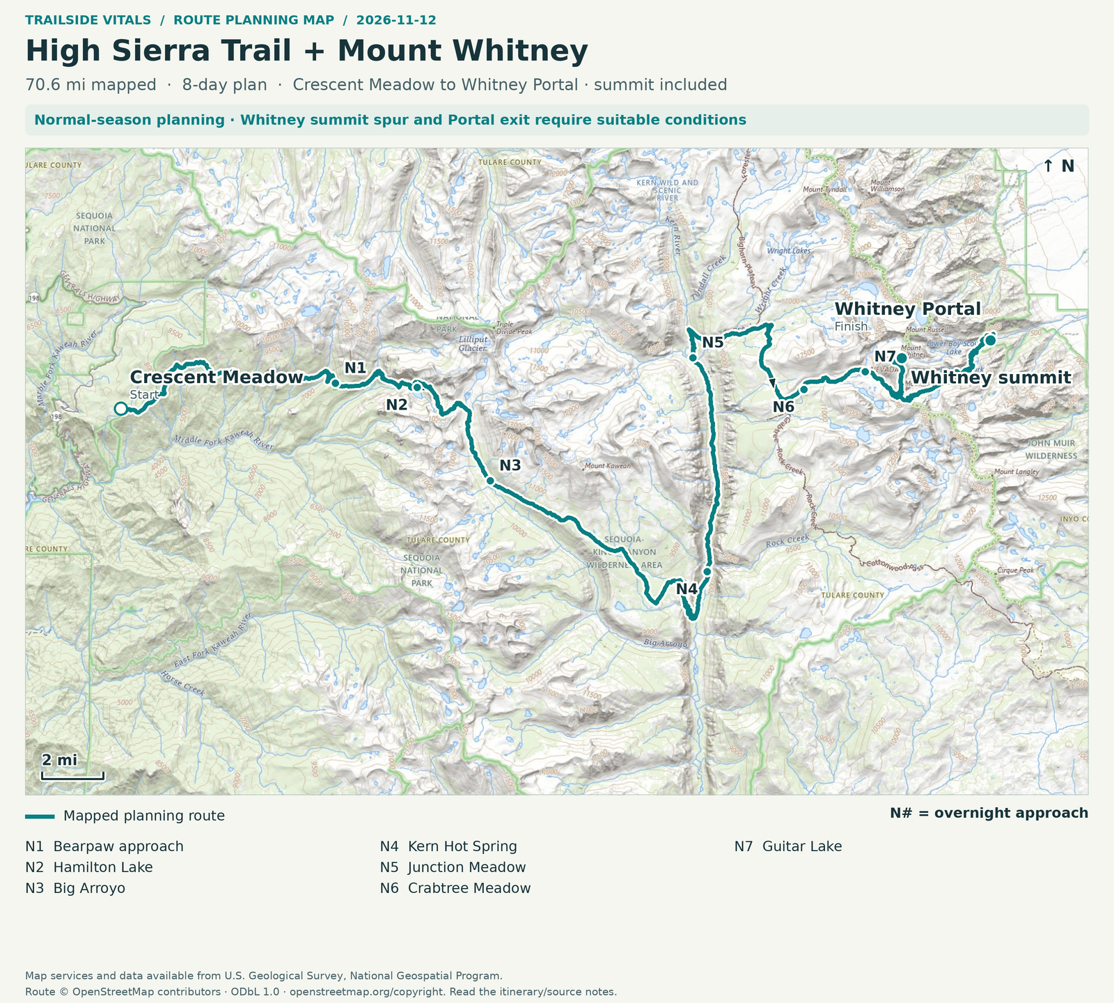
High Sierra Trail + Mount Whitney | Full trip | Planning

Overnight markers derive from the supplied daily track endpoints and may indicate a trail or camping-area approach, not a tent pad.

Plan and day selection update the route, markers, notes, and download together.

Complete-route map preview for High Sierra Trail to Mount Whitney / Whitney Portal
Complete-route preview

Map loading. GPX downloads are available below.

Download complete-route GPX

Map data © OpenStreetMap contributors. Open Database License (ODbL) 1.0.

Route sources, alignment, access and conditions notes

Dated access and conditions note

Planning route only; check current land-manager conditions before travel.

Crescent Meadow / High Sierra Trail western trailhead – Trailhead

Open location on OpenStreetMap (external map)

Reservations & costs

West-origin permit agency

A Crescent Meadow start uses Sequoia/Kings Canyon permission, not a default Whitney Portal entry lottery.

More about West-origin permit agency

Starting at Crescent Meadow means applying for a Sequoia & Kings Canyon wilderness permit. NPS directs west-side hikers to that agency; the Inyo Mt. Whitney entry process is for hikers starting at Whitney Portal. Exiting at Whitney Portal does not by itself mean you should buy its entry lottery permit.

Record the Whitney exit

Have the issuing office confirm the intended continuous route, Whitney travel and Portal exit.

More about Record the Whitney exit

A separate issue is ensuring the issued entry permit accurately authorizes the intended continuous route, Whitney travel and Portal exit. Record the desired exit and confirm it with the issuing wilderness office. A generic permit, an unrecorded route change or a Whitney day-use permit does not cover every variant. Inyo specifically says day-use and overnight permits are not interchangeable, and an overnight Whitney Trail entry permit is not permission for unrelated climbing routes.

West-origin exit permission

Inyo-origin Trail Crest exit wording does not by itself establish an extra requirement for this west-origin trip.

More about West-origin exit permission

Inyo's separate Recreation.gov wording about “Mt Whitney (Trail Crest Exit)” appears in a separate permit process. It applies within an Inyo permit workflow and is not sufficient by itself to impose Inyo-origin exit quota mechanics on a Sequoia-origin trip. Follow NPS's explicit west-origin agency guidance and seek route-specific confirmation; an additional permit requirement is not established by conflicting summaries.

Dated quota-season rules

The cited quota dates and fees are for 2026; the free non-quota window is not a safety or road-access guarantee.

More about Dated quota-season rules

For 2026, NPS lists quota season May 22–September 26, reservations up to six months ahead, and a fee of $15 per trip plus $5 per person. It lists September 27, 2026–May 20, 2027 as free, self-issued non-quota travel. These dates apply to the stated season; check the 2027 quota calendar separately. A reservation still needs the required issuance/orientation process and the correct trailhead.

Sequoia/Kings Canyon wilderness permit, 2026 quota season

Published 2026 entry-permit charge, not a full crossing price.

Basis
$15/trip + $5/person
Inclusions / exclusions
Entry authorization; no guide, transport, park entrance, supplies or hotel included.

Non-quota wilderness permit

Free permission applies only to the stated non-quota window.

Basis
$0, self-issued in published 2026–27 non-quota window
Inclusions / exclusions
Does not remove winter hazards or imply road access.

Whitney Portal entry products

Do not automatically buy an unrelated Whitney Portal entry product.

Basis
Not the default purchase for this west-origin route
Inclusions / exclusions
Inyo entry/day/overnight products have their own rules; no duplicate permit charge assumed.

Transfer, accommodation, food, gear, guide

No full-route transfer or trip quote was verified.

Basis
Current route/date-specific quotes required
Inclusions / exclusions
No complete crossing cost or fixed transfer fare verified.

Preparation

Equipment, preparation and constraints

Prepare for high-elevation weather, sustained food carriage, food-storage compliance and travel between legal camps. Obtain current park food-storage, fire, waste and water advice before finalizing the kit. This source set does not establish one universal canister/food-locker solution for the complete route, so verify the requirements for all planned camps rather than infer that fixed lockers will be available.

Carry offline mapping and a documented communications/overdue plan. Build acclimatization into the wider trip and be prepared to descend or abandon the summit if unwell. Technical snow travel requires competence, not just a purchased axe or traction device. Neither personal experience nor medical advice is claimed here.

Sources & references

General adventure information

Article research and source-date qualifications

Planning options sources

Planning options use the general references above.

Itinerary sources

Itinerary checked on October 30, 2026.