

Follow the Nāpali Coast’s cliffs and valleys to a remote camp at Kalalau. The trail leaves Hāʻena State Park and reaches Kalalau Valley after an official 11-mile approach over exposed, uneven terrain. A round trip requires the right permit, a full-return plan, weather and water margin, and a legal overnight plan where applicable. Expect demanding backcountry travel, not an easy beach walk.

Kalalau Trail to Kalalau Valley
Location: Hawaii — Kauai
Follow the Na Pali cliffs to a remote valley and beach camp.
Essential facts
- Challenge
- Strenuous
- Planning duration
- 3–4 days
- Route distance
- 19.3 mi GPX-derived horizontal estimate (not official). Variant: Kalalau Trail | Full trip | Planning.
Overview
At a glance
- Cost & booking summary
- Beyond Hanakapiai requires the Nāpali wilderness camping permit even without camping. Hāʻena arrival/parking or shuttle is separate. Current numeric fees were not verified; obtain current quotes from the state booking portal.
See dated prices & planning options
Prices, access, entry and operating details below are dated research, not live availability or a booking guarantee.
Before you book or set out
- Access: Beyond Hanakapiai requires a valid Nāpali Coast wilderness camping permit even if not camping. A Hāʻena reservation, parking payment or shuttle ticket is not a substitute.
- Camping: Only Hanakoa and Kalalau are authorized; maximum five nights including Hanakoa. No separate Hanakoa-only permit. Confirm the current 90-day window and overnight arrival arrangements.
- Safety: Never cross flooded streams or enter swift water above knee height. Turn back for unsafe crossings, severe weather or rockfall; no mobile coverage, drinking-water or emergency service is promised.
- Restrictions: Commercial guiding and boat pickup/drop-off need special-use authority. Check closures and seasonal hunting notices; ocean swimming is not recommended without experienced local-condition knowledge.
Route alternatives, season & research details
Route, permitted camps and season
The state describes an 11-mile trail from Hāʻena to Kalalau Valley and places Hanakoa roughly six miles from the trailhead. Camping is limited to Hanakoa and Kalalau; a Kalalau permit can cover a Hanakoa stopover, but does not authorize camping elsewhere. The park stay is capped at five nights, including Hanakoa nights; no permit is issued specifically for Hanakoa. Do not divide this route into unsupported daily mileages or prescribe a camp sequence.
Route & getting there
Check which access permission you need: Hanakāpīʻai day-use access requires Hāʻena entry and parking reservations through Go Hāʻena; going beyond Hanakāpīʻai requires a valid Nāpali Coast State Wilderness Park camping permit even when not camping. The state does not issue a separate stand-alone hiking permit for that continuation. Parking, shuttle, day-use and wilderness camping reservations are separate; none substitutes for the others.
Route map & GPX
Kalalau Trail | Full trip | Planning
Overnight markers derive from the supplied daily track endpoints and may indicate a trail or camping-area approach, not a tent pad.
Plan and day selection update the route, markers, notes, and download together.
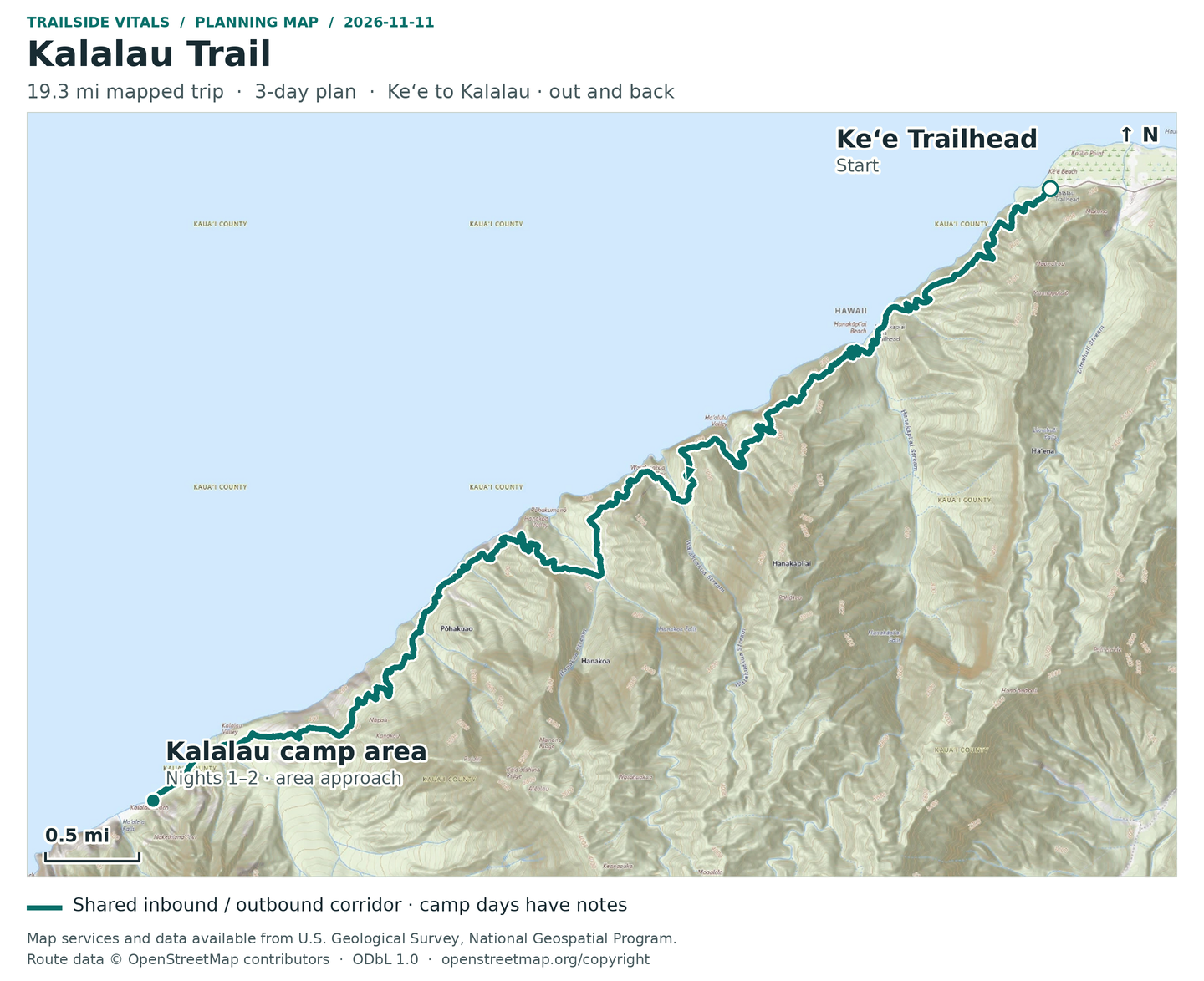
Map loading. GPX downloads are available below.
Map data © OpenStreetMap contributors. Open Database License (ODbL) 1.0.
Route sources, alignment, access and conditions notes
Dated access and conditions note (November 11, 2026)
State access notices require confirmation: indexed November 10 information reports a November 2 reopening for Kalalau overnight camping, while the notice page also retains broad Kauaʻi camping/storm closure language. This pack does not resolve that conflicting notice into an unconditional open/closed claim. Confirm directly with DLNR State Parks before travel. A Nāpali Coast permit is needed beyond Hanakāpīʻai; arrange the separate Hāʻena parking/shuttle/entry access. Storms, stream flooding, surf and exposed cliff sections can make the normal route unusable. No storm detour is invented.
Searchable points
WGS 84 latitude, longitude. Decimal places do not imply survey accuracy.
22.2204209, -159.5827142 | Keʻe / Kalalau Trailhead | on mapped trail; reference offset 0 m
22.1734133, -159.6570881 | Kalalau authorized camp-area approach | on mapped trail; reference offset 24 m
Haena State Park access area – not the exact Kalalau trailhead – Destination area
Approximate location – not an exact point. Check the source before travelling.
Reservations & costs
Preparation
Clear streams can become muddy torrents quickly: never cross a flooded stream, and do not enter swift water above knee height. The trail has steep drop-offs, loose rock, roots and mud, with no mobile coverage or emergency services. Treat stream water; there is no drinking-water or trash service. Ocean swimming is not recommended except for experienced swimmers familiar with local conditions; there are no lifeguards. Turn back for unsafe crossings, severe weather or rockfall—not around them.
No best month or guaranteed open date is established here. Check DLNR notices, access reservations, weather and water conditions before each trip. Summer does not make surf safe. DLNR also notes hunting may occur above the trail or in Kalalau Valley on some August/September weekends; follow posted safety zones and main trails.
Recommended gearExplore our backpacking gear recommendations
Keep flooded-stream and ocean warnings; no purchase changes a decision to turn back.
Sources & references
General adventure information
Article research and source-date qualifications
- H23-1: Kalalau Trail. Source period: current as of 2026-10-30.
- H23-2: Nāpali Coast State Wilderness Park information. Source period: current as of 2026-10-30.
- H23-3: Kalalau Trail Safety Concerns. Source period: current as of 2026-10-30.
Planning options sources
Planning options use the general references above.