

Trailside VitalsExplore
A small alpine lake borders red and golden tundra below the snowy peaks of Denali and the Alaska Range.
Fall colors on Kesugi Ridge. Denali State Park, Alaska – Paxson Woelber; responsive crops/resizing by Trailside Vitals. / Creative Commons Attribution 2.0 Generic (CC BY 2.0)

K’esugi Ridge, Little Coal Creek to Byers Lake

Location: Alaska — Denali State Park

Travel open tundra ridges facing the Alaska Range, with Denali views when weather allows.

Essential facts

Challenge
Hard
Planning duration
3–4 days
Route distance
28.9 mi

Overview

K’esugi Ridge offers a sustained journey above the forest, with rolling alpine ground, small glacially scoured lakes and a changing view across the valley toward the Alaska Range. Denali views depend on the weather; cloud can hide the mountains and the route.

DNR describes this as challenging country requiring map-and-compass competence and a willingness to turn around or wait out poor weather. Be ready to navigate independently and leave flexibility in your pickup plan.

Route identity, metrics and variants

The North map labels Little Coal Creek Trailhead at Parks Highway mile 163.9, the 3.3-mile Little Coal Creek access trail, a 10.8-mile ridge section to the Ermine Hill junction, and Ermine Hill Trailhead at mile 156.5. Ermine Hill's 3.7-mile access trail is a different entry/exit, not a compulsory detour on this traverse. The South guide gives 11.2 miles between the Ermine Hill and Cascade junctions, 2 miles for Cascade Trail, and a 5.3-mile Byers Lake loop. Do not insert the entire lake loop or Ermine Hill spur into the selected route. These are published segment definitions, not apportioned days.

The South map visibly distinguishes the Cascade descent from continuation toward Tarn Point / Upper Troublesome Creek and labels the different approaches around Byers Lake. The 2017 panel describes Cascade as 3.5 miles from the campground to the ridge, whereas the system guide's 2-mile Cascade segment starts at the lake-loop junction; the campground approach is additional. Keep the start/end scope attached to each metric rather than calling these interchangeable distances. No complete ascent/descent total is published here: the North guide gives Little Coal Creek gain as 1,750 feet, while the older park brochure/panel gives 2,200 feet. Those figures are not averaged or added into a new profile.

Finish at Byers Lake, not K’esugi Ken. The panel identifies K’esugi Ken Campground at mile 135.4 and its Curry Ridge Trail to an alpine lake, separately from Byers Lake at mile 147 and the K’esugi Ridge/Cascade system. The map shows the campground and Curry Ridge visitor area, but no verified extension from this traverse to K’esugi Ken. A 37-mile Little Coal Creek–Upper Troublesome Creek option in the guides/panel also has a different endpoint and is separate from both K’esugi Ken and the Byers Lake traverse. No extension distance or connecting permission is inferred.
At a glance

Cost & booking summary
Undated DNR tariffs list $5 daily parking at each road end and $20/site developed Byers Lake camping. Confirm multiday parking treatment. Ordinary small-party backcountry camping has no general permit requirement, but unit/special-use rules apply; shuttle quote separate.

See dated prices & planning options

Before you book or set out

  • Transport: Arrange pickup/drop-off before setting out. This traverse ends at Byers Lake, not K'esugi Ken; no connecting extension to that campground is established.
  • Conditions: Carry map/compass competence and warm rainproof equipment for exposed ridge weather and summer hypothermia. Check current DNR closures, bear notices and forecast; retain delay supplies.
  • Camping and fire: Ordinary private backcountry camping differs from commercial/organized/large-group use and unit rules. Use a stove, not open ridge fires; Byers Lake sites are first come, not online-reserved.
  • Water and route: Purify water and confirm current food-storage advice. Dated Upper Troublesome status conflicts do not clear that separate exit; the selected route uses Cascade toward Byers Lake.
Route alternatives, season & research details

Prices, access, entry and operating details below are dated research, not live availability or a booking guarantee.

Route & getting there

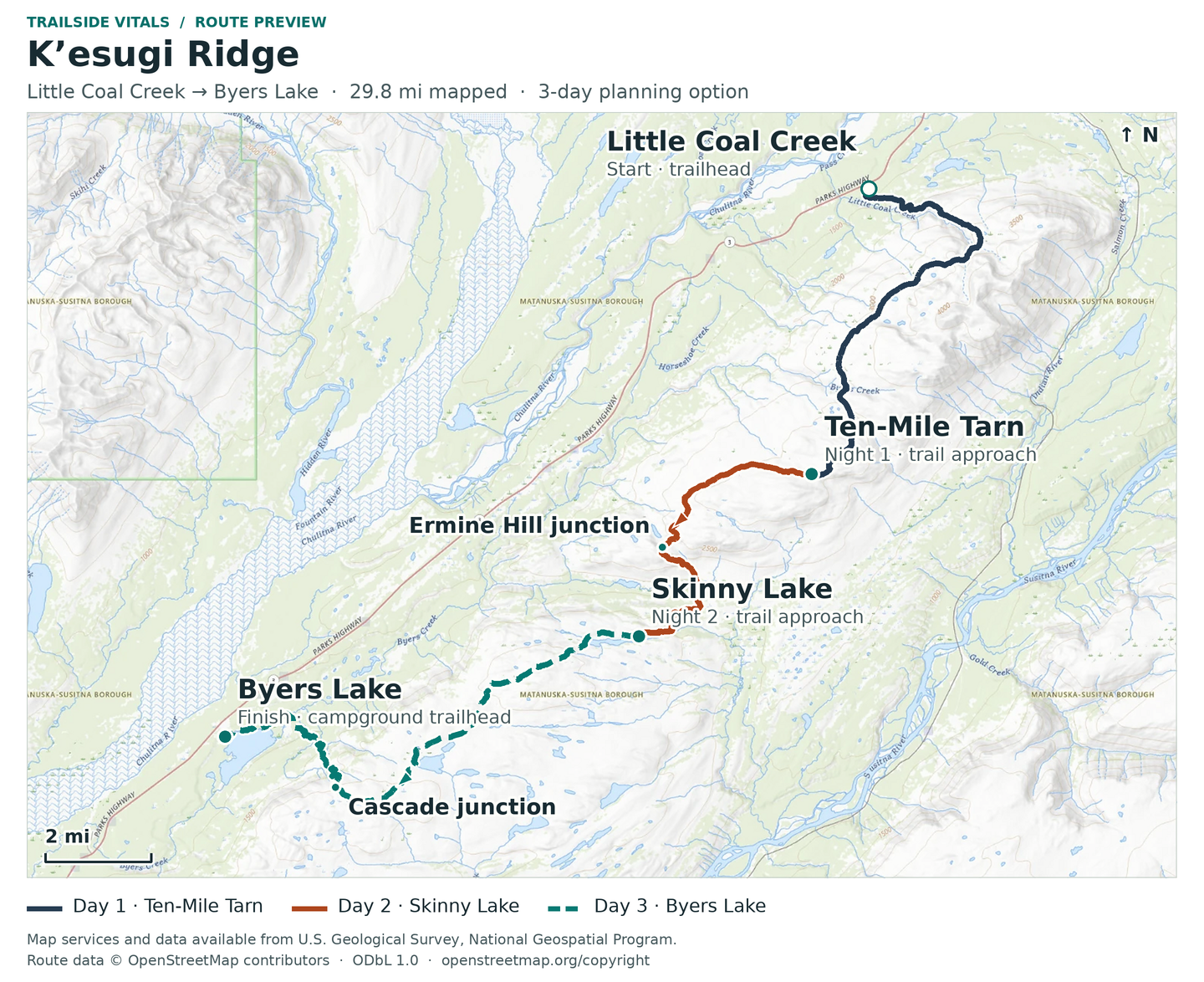
The researched alignment is north to south from Little Coal Creek Trailhead, along K’esugi Ridge past the Ermine Hill junction and Skinny Lake sector, then down Cascade Trail and around the appropriate Byers Lake connection to Byers Lake Campground. DNR's North guide explicitly publishes 28.9 miles for Little Coal Creek Trailhead–Byers Lake Campground. That is the source’s whole-route figure, not a daily schedule. Both system guides say north-to-south travel is common because it has less total elevation gain and require pickup/drop-off arrangements before departure.

Route map & GPX

K’esugi Ridge | Little Coal Creek to Byers Lake | Planning

Overnight markers derive from the supplied daily track endpoints and may indicate a trail or camping-area approach, not a tent pad.

Plan and day selection update the route, markers, notes, and download together.

Complete-route map preview for K'esugi Ridge, Little Coal Creek to Byers Lake
Complete-route preview

Map loading. GPX downloads are available below.

Download complete-route GPX

Map data © OpenStreetMap contributors. Open Database License (ODbL) 1.0.

Route sources, alignment, access and conditions notes

Dated access and conditions note

Planning route only; check current land-manager conditions before travel.

Little Coal Creek trailhead – northern Kesugi Ridge access – Trailhead

Open location on OpenStreetMap (external map)

Reservations & costs

Party and permit categories

Ordinary small private camping differs from commercial, organized or large-group special-use permission. Park-unit and camp-location restrictions still apply.

More about Party and permit categories

Alaska State Parks' current general FAQ says ordinary backcountry camping does not require a permit, and allows camping in designated areas or at least one-half mile from facilities. It also cautions that individual park units may have special rules. This is not permission to camp anywhere, occupy a closed area or run a commercial/group event: the FAQ separately identifies guided trips, organized events and groups of 20 or more as special-use cases. Guided trips need their own authorization; this plan is for an independent small party.

Backcountry versus campground

Byers Lake sites are first come, with no online reservations; the old Skinny Lake map is not a reserved camp or current facility guarantee.

More about Backcountry versus campground

The older trail brochure identifies Skinny Lake as its designated ridge campsite/restroom location. Treat that as a mapped planning reference, not a reserved tent pad or proof of current facilities. The current Byers Lake page says developed campsites are first come, first served, with no online reservations, and lists a 15-day camping limit. A cabin rental, a developed campground stay and ridge camping are different arrangements; availability of one does not authorize or reserve another.

Stove and weather preparation

Use a camp stove and retain weather-delay supplies. An old gravel-bar exception is not general ridge-fire permission.

More about Stove and weather preparation

Use a camp stove. The system guides and current FAQ prohibit open backcountry fires and direct visitors to designated fire rings for permitted fires. The older brochure's gravel-bar exception is not promoted as a general ridge-camping option. Pack current maps offline, leave a route/return plan with a reliable contact and retain time and supplies for a weather delay.

Point-to-point transport

Arrange both road ends in advance. The researched shuttle is a separately quoted provider service, not an included or booked transfer.

More about Point-to-point transport

Little Coal Creek and Byers Lake are different road ends. Denali Southside River Guides' own Denali Shuttle page explicitly offers service to/from Little Coal Creek Trail Head and Byers Lake Campground, as well as Ermine, Troublesome and K’esugi Ken. It encourages advance booking and requires an availability/price enquiry. DNR independently links this business for backpacker shuttles. This establishes a relevant provider, not a booked departure, an included transfer or a guaranteed operating season.

Little Coal Creek Trailhead parking

Trailhead daily parking does not establish an unlimited multiday tariff.

Published basis / amount
$5 daily parking fee
Evidence and limitation
Current DNR table; general note says overnight parking requires two daily payments. Confirm payment coverage for the actual multi-day stay rather than assuming a single $5 payment or inventing a three/four-day total.

Byers Lake parking

Separate Byers Lake parking rate; confirm multiday treatment.

Published basis / amount
$5 daily parking fee
Evidence and limitation
Separate fee-table row; actual vehicle placement and annual-pass coverage require a travel-date check.

Byers Lake developed camping

Developed-site camping is not a ridge permit or reservation.

Published basis / amount
$20 per site
Evidence and limitation
Fee-table camping column; developed camping, not a per-person ridge permit. First-come rules and live operation from campground page; not an included night or reserved site.

Ordinary backcountry permit

No ordinary backcountry permit fee does not waive unit-specific restrictions.

Published basis / amount
No permit required per current general State Parks FAQ
Evidence and limitation
No ordinary backcountry permit purchase is required. Special unit rules and special-use categories remain distinct; no blanket claim that every service/access is free.

Trailhead shuttle

No numeric shuttle fare or seat was verified.

Published basis / amount
Enquiry / dated party-and-route quote
Evidence and limitation
Both endpoints explicitly served; operator publishes no fare on the page. Availability, dates, luggage and cancellation terms unverified.

Cabin, lodging, equipment, food, fuel and travel

No complete trip budget was verified.

Published basis / amount
Live quote
Evidence and limitation
Optional separate purchases; no fixed “from” package price is established.

Price date & basis

Current web tariffs are undated; they are not 2027 guarantees. No complete trip price is verified.

Preparation

Season, exposure and preparation

The park trail brochure recommends late June to mid-September, but it is an older document, not a forecast or a guarantee of seasonal opening. It describes an exposed ridge, a northern trail high point of 3,550 feet, and the need to hunker down in poor weather. Carry warm rainproof equipment even in summer: DNR explicitly warns of summer hypothermia. Low clouds can demand navigation rather than simply reduce the view.

Both system guides warn that weather changes fast and some trails may close seasonally because of high bear concentrations. Check the actual route's current DNR notices and forecast immediately before travel; neither a map's availability nor a campground listing certifies that a trail is open. The older brochure calls Upper Troublesome Creek impassable/under repair, while the 2017 panel describes that trail normally. These conflicting older descriptions do not establish whether that trail is open in October 2026. It is not the selected Byers Lake exit.

Water shown on a map is not guaranteed potable or available at every proposed camp. DNR says to purify drinking water to avoid giardiasis, make noise to avoid surprising bears, and minimize backcountry impacts. The older brochure mentions possible bear-resistant-container availability at the Veterans Memorial visitor center, but this is not a verified current rental programme, stock promise or universal equipment mandate. Confirm current food-storage advice and carry adequate food protection without relying on a historic loan reference.

Sources & references

General adventure information

Article research and source-date qualifications

Planning options sources

Planning options use the general references above.