

Trailside VitalsExplore
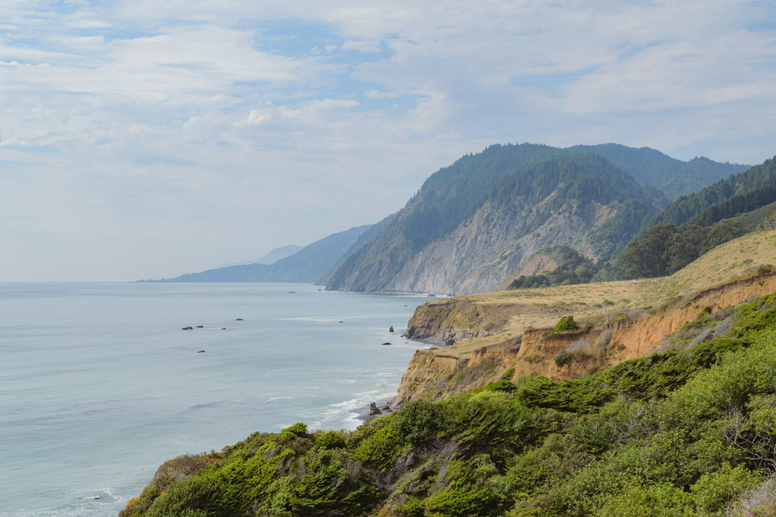
Rugged coastal cliffs, golden grass and green hills stretch along the Pacific on California's Lost Coast.

Lost Coast, Mattole to Black Sands Beach

Location: California — King Range

Walk a rugged coastline where the mountains meet the ocean and roads disappear.

Essential facts

Challenge
Hard
Planning duration
3–4 days
Route distance
24.6 mi

Overview

On the northern Lost Coast, the route is pressed between the Pacific and the King Range. Walk exposed beaches and shifting footing where the mountains squeeze the coastline against the water. Wildflower-covered slopes, tidepools and the possibility of seeing marine mammals give the trip a distinct natural-history focus.

BLM names sea lions, elephant seals, otters and eagles among the area's wildlife; sightings are not guaranteed. Observe from a respectful distance and do not let an animal encounter force a party into surf.

BLM describes the northern route as 24.6 miles and moderately level. That is not equivalent to easy: sand, cobbles, weather, creek crossings and enforced waits make progress different from a graded inland trail. This route suits self-sufficient backpackers willing to put tide feasibility ahead of a booking calendar. Hard is Trailside’s approved Challenge assessment for the complete adventure; the agency’s description concerns its elevation profile.

Tides determine whether a through-walk is possible: on some dates, safe passage cannot be planned. An entry permit confirms authorization, not that every beach can be crossed.
At a glance

Cost & booking summary
Current booking tariff: $6/permit plus $12/person/trip Special Area Fee, waived under 16; separate refund terms apply. Published BLM canister rental is $5/trip, stock/return to confirm. Shuttle and travel are separate.

See dated prices & planning options

Prices, access, entry and operating details below are dated research, not live availability or a booking guarantee.

Before you book or set out

  • Tides before payment: Establish complete safe passage windows before buying the permit. Enter on receding tides; detailed listing thresholds are under 6 ft Punta Gorda, under 2.5 ft Sea Lion Gulch-Randall Creek and under 3 ft Miller Flat-Gitchell Creek.
  • Safety: Thresholds are not surf or weather clearance. Conflicting 2026 impassable-date blocks do not establish a complete calendar; retain time and supplies to wait or turn back.
  • Permit: Reserve the actual overnight start and confirm release/pickup rules. Conflicting office walk-up schedules are not a dependable fallback. Commercial/organized use needs separate authority.
  • Storage: Carry hard-sided bear-resistant storage for food, waste and toiletries, plus water treatment and a compliant waste plan. Confirm any rental stock and return arrangements.
Route alternatives, season & research details

Variants, season and tide zones

This route runs from Mattole to Black Sands Beach, not through the southern Lost Coast in Sinkyone Wilderness State Park. BLM describes the latter separately, with different land management and camping rules. Do not combine a northern beach trip with a southern forest itinerary under one permit explanation. Reverse travel also changes the transport arrangement and the order in which tide-dependent areas are reached.

BLM identifies three areas needing particular care: near Punta Gorda, Sea Lion Gulch to Randall Creek, and Miller Flat to Gitchell Creek. Its route page advises passing tide-constrained stretches on an outgoing tide of three feet or less. That threshold is not an all-weather guarantee, a permission to start at the moment the predicted tide reaches three feet, or evidence that the whole constrained section can be finished in one window. Use the agency's detailed tide-safety material, current predictions and actual surf to establish entry, complete passage and escape options.

Use the detailed tide limits: the official permit listing gives zone-specific thresholds: Punta Gorda under six feet, Sea Lion Gulch–Randall Creek under 2.5 feet, and Miller Flat–Gitchell Creek under three feet, always entering on a receding tide. Thus the broad three-foot summary is inadequate for Zone 2. Use the detailed lower threshold and a full passage calculation, not the general route-page shorthand. The listing's two 2026 impassable-date blocks differ, so no complete calendar is reproduced here; both identify October 30 as impassable.

The King Range page specifically says to check tide feasibility before purchasing a permit, because on many dates tides make traversing the trail impossible. Check tide feasibility first, then buy the permit. Build capacity to wait; do not make a fixed shuttle or flight a reason to enter a narrowing beach. Winter weather and high water deserve separate assessment even when tide predictions look favorable.

Route & getting there

Arrival, transfers and overnight choices

The usual north-to-south logistics place the car at Black Sands Beach in Shelter Cove and shuttle to Mattole before walking back. Lost Coast Adventure Tours' official page describes exactly that service and also offers reverse/custom arrangements by enquiry. It does not establish a current fare, guaranteed seat, luggage limit or cancellation policy. Treat its “only licensed” language as the operator's own claim, not an independently audited exclusivity statement.

Book the shuttle only after the tide plan and permit agree. Allow a mainland arrival night and a buffer after the walk before flying onward. Remote roads and coastal conditions can delay you. BLM explicitly prohibits camping at Black Sands Beach trailhead and says camping is allowed north of Telegraph Creek. A parking endpoint is not an authorized last-night camp.

Route map & GPX

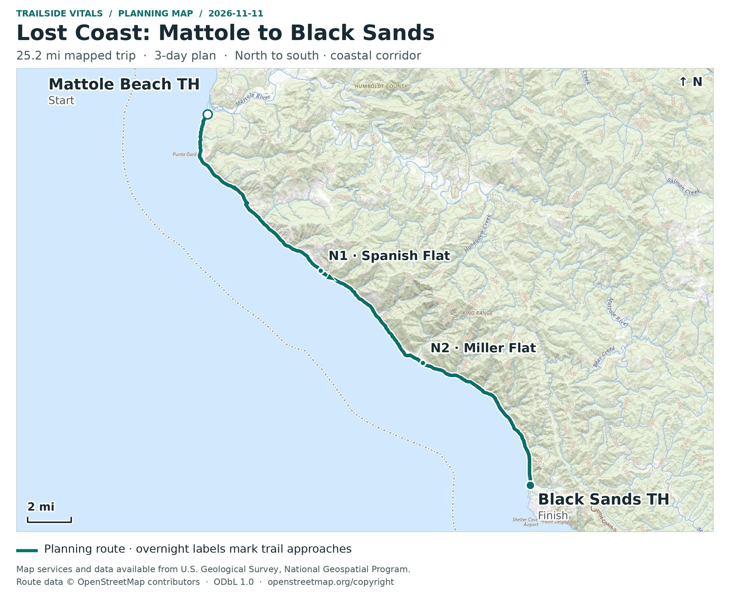
Lost Coast: Mattole to Black Sands | Full trip | Planning

Overnight markers derive from the supplied daily track endpoints and may indicate a trail or camping-area approach, not a tent pad.

Plan and day selection update the route, markers, notes, and download together.

Complete-route map preview for Lost Coast, Mattole to Black Sands Beach
Complete-route preview

Map loading. GPX downloads are available below.

Download complete-route GPX

Map data © OpenStreetMap contributors. Open Database License (ODbL) 1.0.

Route sources, alignment, access and conditions notes

Dated access and conditions note (November 11, 2026)

BLM identifies three tide-sensitive sections: Punta Gorda (about 6 ft threshold), Sea Lion Gulch–Randall Creek (2.5 ft), and Miller Flat–Gitchell Creek (3 ft). Thresholds alone do not establish a safe passage: use current official instructions, local tides, a falling tide with time to exit, surf and weather. The older December 2025 roads/trails report describes landslide hazards north of Buck Creek and passing east of Split Rock; it is not a current opening guarantee. Do not cross the ocean or climb bluffs to follow a GPX. A King Range overnight permit and required food storage are separate requirements.

Searchable points
WGS 84 latitude, longitude. Decimal places do not imply survey accuracy.
40.2890180, -124.3560412 | Mattole Beach Trailhead | on mapped trail; reference offset 4 m
40.0452141, -124.0786316 | Black Sands Beach Trailhead | on mapped trail; reference offset 7 m
40.1863485, -124.2587476 | Night 1: Spanish Flat camping-area approach | cumulative 10.20 mi
40.1257709, -124.1710464 | Night 2: Miller Flat south-of-creek camping-area approach | cumulative 16.87 mi

Mattole Campground access area – northern Lost Coast entry – Trailhead

Approximate location – not an exact point. Check the source before travelling.

Open location on OpenStreetMap (external map)

Reservations & costs

Overnight permit and area fee

Check all tide windows before buying the start-date permit; the reservation fee alone is not the full current charge.

More about Overnight permit and area fee

Overnight use of the King Range Wilderness and Backcountry Management Zone requires a reserved wilderness permit. BLM's permit page publishes $6 per permit for reservations, but the live official booking listing adds a $12/person/trip Special Area Fee, with no area fee for youth under 16. The $6 alone is therefore not a complete current permit cost. The area page says three-month rolling reservations; the booking listing says 90 days and supplies calendar examples that resemble three months. Check the actual release date rather than treating those expressions as identical.

Private party versus commercial use

Group and commercial permissions are separate; an independent permit does not authorize selling a guided departure.

More about Private party versus commercial use

The area page says a person may reserve one permit at a time for up to three starts/people and identifies a maximum group size of 15. An organized party still needs the correct group permission; separate reservations do not bypass it. Commercial or organized groups require separate Special Recreation Permit review; the public private-party permit does not authorize a commercial guided departure. BLM's posted commercial/group conditions include holiday restrictions and a separate application process.

Do not rely on walk-up wording

The published office schedules conflict. Obtain current guidance instead of arriving on an assumed walk-up date.

More about Do not rely on walk-up wording

BLM’s published walk-up schedules conflict: the trail page lists Monday–Saturday and a May 30–September 5 window, while the area page describes weekday sales with weekend permits on Friday. These are not a dependable basis for arriving without a reservation. Obtain current office guidance before relying on a walk-up fallback.

Wilderness reservation and Special Area Fee

Reservation plus per-person trip fee, with youth exemption and separate refund conditions.

Basis
$6/permit plus $12/person/trip; area fee waived under age 16
Inclusions / exclusions
Current official booking tariff. $6 non-refundable; area-fee refund requires cancellation/reduction at least seven days before entry. Not shuttle or commercial-group permission.

BLM canister rental

Published canister rental and replacement terms require stock/return confirmation.

Basis
$5/canister/trip; $75 replacement charge if not returned
Inclusions / exclusions
Published agency rental terms; confirm availability, return location and whether still operating as listed. Other suppliers set their own rates.

Shuttle

No shuttle fare or departure is confirmed.

Basis
Route/party/departure quote required
Inclusions / exclusions
Traditional and reverse options exist; fare, minimum loading and cancellation not verified.

Travel, lodging, food, gear

No all-in trip or guide price was established.

Basis
Separate costs
Inclusions / exclusions
No supported all-in trip price, guide fee or insurance inclusion.

Preparation

Equipment, preparation and constraints

BLM requires hard-sided bear-resistant canister storage for food, rubbish and toiletries. Its area page publishes agency rental information, but capacity, collection hours and stock need confirmation. Do not confuse the canister requirement with carrying bear spray, or assume a full party's food fits one small rental. The official page notes no backcountry bathrooms or amenities; prepare a compliant waste plan and carry out rubbish.

Bring tide information, a passage map, watch, weatherproof shelter, offline navigation and footwear suited to abrasive, uneven footing. BLM says beach water sources are plentiful; that does not make untreated creek water potable or guarantee a selected source after unusual weather. Confirm treatment and collection away from seawater. A communications plan, food reserve and conservative creek assessment are sensible precautions; rescue is not immediate or guaranteed.

Sources & references

General adventure information

Article research and source-date qualifications

Planning options sources

Planning options use the general references above.