

Trailside VitalsExplore
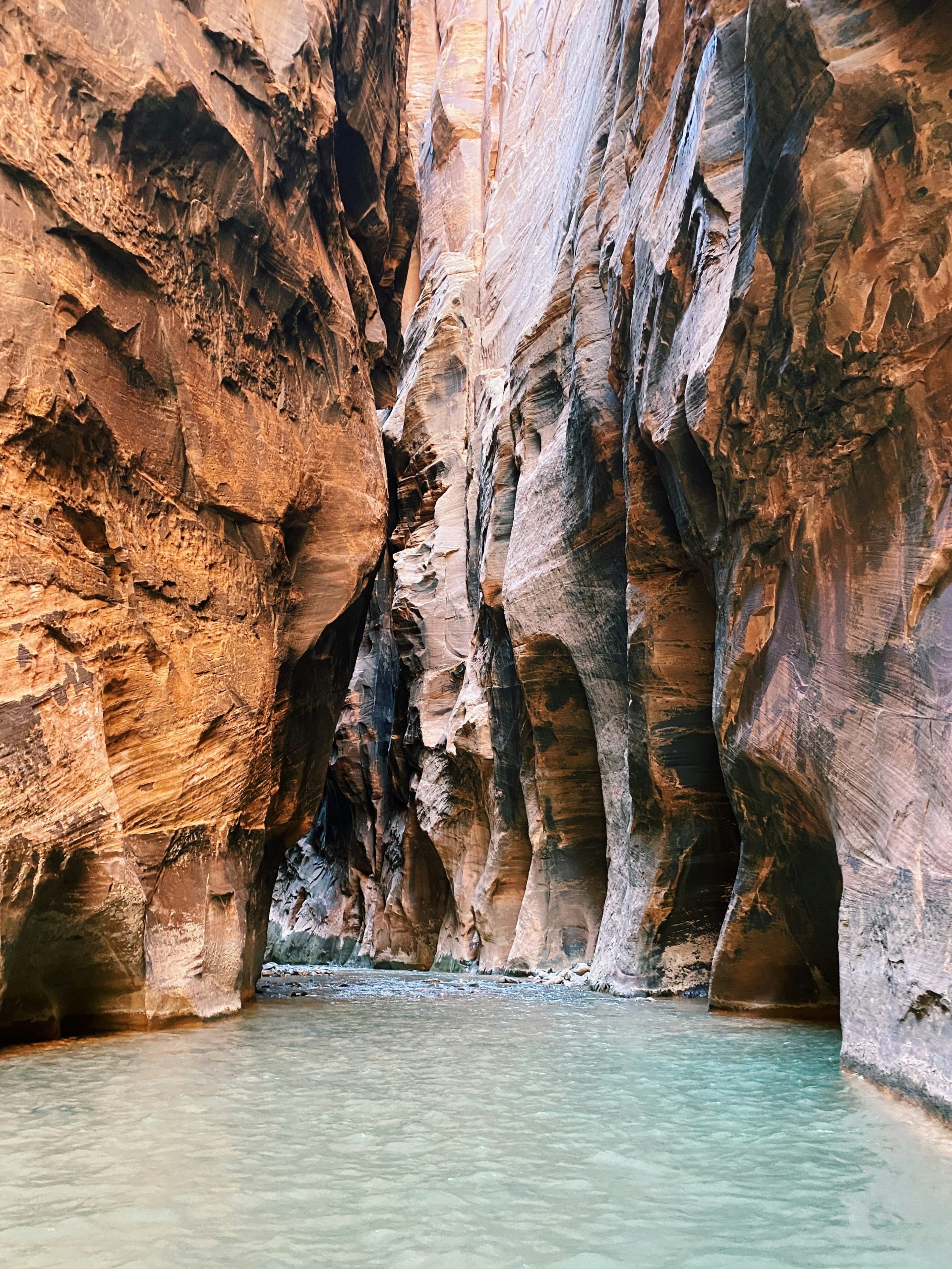
Pale turquoise water flows between tall sandstone walls in the Wall Street section of the Narrows.

The Narrows, top-down

Location: Utah — Zion

Wade downstream through the Virgin River’s towering sandstone gorge, with an overnight at an assigned riverside camp.

Essential facts

Challenge
Strenuous
Planning duration
1–2 days
Route distance
16.0 mi

Overview

The National Park Service describes the top-down Virgin River Narrows as a 16-mile one-way route from Chamberlain’s Ranch to Temple of Sinawava, with about 1,300 feet of elevation change. Estimated hiking time is 10–14 hours, and NPS says at least 80% of the route involves wading, walking or swimming in the river.

There is no maintained trail: the river itself is the route, with cold water, swift current and slippery rocks.

The sandstone corridor narrows to as little as 30 feet in places while rising up to 1,000 feet high. This is a permitted backcountry river crossing, not a conventional path hike. NPS warns that water depth can exceed a person’s height and that top-down hikers must be prepared for swimming sections.

At a glance

Cost & booking summary
Published permit components: day use $6 nonrefundable reservation plus $10/person refundable; overnight $20 nonrefundable permit plus $7/person/night refundable. Confirm the selected product; park entrance and start transfer are separate.

See dated prices & planning options

Prices, access, entry and operating details below are dated research, not live availability or a booking guarantee.

Before you book or set out

  • Permit: Both top-down day and overnight trips need a nontransferable wilderness permit, collected in person by the holder the day of or day before travel. Overnight travel uses assigned camps and the downstream direction.
  • Closures: Top-down trips close above 120 cfs. A Flash Flood Warning closes the river until at least two hours after it lifts; a reservation does not override closure.
  • Safety: Expect prolonged cold-water wading and possible swimming. Check flow and flood outlook; choose another hike if the party cannot handle immersion and uneven footing.
  • Water and transport: Carry safe drinking water; ordinary filters do not remove the Virgin River cyanotoxin risk. Arrange Chamberlain's Ranch access separately and leave margin for the exit shuttle.
Route alternatives, season & research details

Route/experience variants and season

  • Top-down day through-hike: Chamberlain’s Ranch to Temple of Sinawava, 16 miles one way. NPS estimates 10–14 hiking hours, but actual progress depends on river depth, footing, weather, group pace and permit closure status. Plan independent transport to the remote start and maintain enough time for the Zion Canyon exit/shuttle if operating.
  • Top-down overnight: the same 16-mile direction split over two days with one night in a designated canyon campsite. NPS lists 12 campsites, roughly halfway along the route. Overnight parties must start at Chamberlain’s Ranch and exit at Temple of Sinawava; upstream travel to campsites is not allowed. Campsite assignment is permit-controlled.
  • Bottom-up Narrows: a different, shorter out-and-back from Temple of Sinawava. It is a different trip, with different permit and access rules from this top-down route.
  • Season and closures: all top-down trips close when Virgin River flow exceeds 120 cubic feet per second; NPS does not issue permits while closed. Spring snowmelt often closes the river in April/May and sometimes later. A National Weather Service Flash Flood Warning also closes the river, and the closure continues for at least two hours after the warning lifts. Check the actual flow, flash-flood outlook and official conditions shortly before hiking.

Suggested itinerary

Suggested independent itinerary. Not a bookable package; confirm access, reservations and current conditions.

Conditional two-day top-down Narrows plan

Walk downstream over two days, staying at the campsite assigned by your overnight permit. Travel only with an issued permit and an open river. This is the same downstream route from Chamberlain's Ranch to Temple of Sinawava, not the bottom-up day walk. Camp assignment, flow, weather and transport determine the actual plan; no daily mileage or timing is promised.

  1. Day 1 Chamberlain's Ranch to the assigned camp

    After collecting the permit and checking river and flash-flood conditions, use the independently arranged start transfer. Travel downstream to the single designated campsite assigned by the overnight permit. Use only your assigned camp; a reservation does not override a river closure.

  2. Day 2 Continue downstream to Temple of Sinawava

    Continue along the permitted river route and exit at Temple of Sinawava. Keep the final shuttle and onward transport margin in the plan; the Zion Canyon shuttle does not provide transport to Chamberlain's Ranch. Abandon or change the trip when official closures or unsafe conditions require it.

Route & getting there

Arrival, transport and overnights

Arrange transport to Chamberlain’s Ranch and pickup or onward travel from the Zion Canyon end. No public connection between them is established here. For a day hike, start early enough to leave a generous walking margin and catch the last exit shuttle if it is operating. The overnight variant still requires the same start/end sequence and only one assigned campsite night.

The park site provides photos of the designated Narrows campsites, but no campsite description, availability or nightly reservation should be inferred from those photos alone. Lodging in Springdale or elsewhere near Zion is separate from the wilderness permit and transport.

Route map & GPX

The Narrows Top-Down | Chamberlain’s Ranch to Temple of Sinawava | Planning

Campsite waypoints are approximate bank-access locations; use the permit campsite directions for final access.

Choose the plan that matches your permit or itinerary.

Complete-route map preview for The Narrows, top-down
Complete-route preview

Map loading. GPX downloads are available below.

Download complete-route GPX

Choose a plan to select a hiking day GPX.

Map data © OpenStreetMap contributors. Open Database License (ODbL) 1.0.

Route sources, alignment, access and conditions notes

Dated access and conditions note (November 10, 2026)

NPS top-down guidance closes the route above 120 cfs and during Flash Flood Warnings, with at least a two-hour closure after a warning lifts. This is a planning file. Permit collection, current river and flood conditions, campsite assignment and start-side transport are required for a trip. Check NPS for the hike date.
The current general conditions page lists 150 cfs for the Narrows more broadly. This record follows the route-specific 120 cfs top-down guidance.
The NPS map used here is its currently linked Narrows-Map-2017.pdf. Current campsite descriptions govern campsite details.

Source geometry
OpenStreetMap relation 13331651 v5, ordered from Chamberlain’s Ranch downstream, with Riverside Walk way 14326787 added to reach Temple of Sinawava.
Source ways in travel order
170322497 v10, 170322512 v8, 1002810973 v4, 1162023753 v2, 1162023754 v2, 1162023748 v2, 1162023750 v2, 1162023749 v2, 1162023752 v2, 1162023751 v2, 170320443 v15, 80339500 v24, 993161889 v2, 14326787 v16
Daily split points are interpolated on the same mapped river segments. Source data was retrieved 2026-11-10.

Chamberlain's Ranch – top-down Narrows trailhead; check permits and closures – Trailhead

Open location on OpenStreetMap (external map)

Reservations & costs

Top-down wilderness permit

Both day and overnight trips need a permit collected in person; river and flash-flood closures can override the reservation.

More about Top-down wilderness permit

Both top-down day and overnight trips require a Zion Wilderness permit. The reservation holder must collect it in person at the Zion Canyon Visitor Center Wilderness Desk the day of or day before the trip, with the necessary vehicle details; allow at least 20 minutes and check current desk hours. Permits are non-transferable. A reservation is not a guarantee that the river will remain open; the park withholds permits during flow/flash-flood closures.

Start transfer and exit shuttle

Arrange Chamberlain's Ranch transport independently and leave a margin for the last Zion Canyon shuttle.

More about Start transfer and exit shuttle

The exit is Temple of Sinawava (Shuttle Stop 9). During shuttle season the Zion Canyon Scenic Drive is generally shuttle-access only; the NPS shuttle ride from the visitor center to the last stop takes about 40 minutes, and the Narrows route page warns hikers not to miss the last bus. Arrange transport to Chamberlain’s Ranch separately. NPS transport to that trailhead is not confirmed here. Book a permitted, reliable transfer to the start.

Day-use permit

Day-use reservation and per-person charges have different refund terms.

Basis
$6 non-refundable reservation/application fee plus $10 per person, refundable
Qualification
NPS applies these fees to day-use/canyoneering permits; confirm the selected top-down permit product and current terms in the live reservation flow.

Overnight permit

Overnight permit and per-person nightly charges are separate.

Basis
$20 non-refundable permit fee plus $7 per person per night, refundable
Qualification
Published NPS wilderness permit schedule; one overnight per designated-site permit.

Zion entrance

Entrance depends on the applicable pass category.

Basis
$20–35 standard pass; valid 1–7 days
Qualification
Exact amount depends on pass/entry category. Walking visitors age 16+ require an individual pass; youth 15 and under are free.

Start-side transport / lodging / equipment

No start-transfer, lodging or equipment quote was verified.

Basis
Live quote
Qualification
No transport operator, lodging availability, rental or cost verified. No total quoted.

Preparation

Preparation, equipment and constraints

NPS identifies slippery uneven river rock, cold water, swift current, flash flooding and hypothermia as hazards. Its Narrows safety guidance warns against jumping between rocks because lower-leg fractures are common; maintain balance and lower down or find another route. Wear closed-toed footwear and use a sturdy walking stick; avoid cotton and carry dry insulation because immersion can chill hikers even in warm air.

Do not drink directly from the Virgin River: the NPS warns of cyanotoxin risk and says ordinary recreational filters do not make river water safe. Carry adequate drinking water from a safe source. The park warns flash floods can occur at any time and recommends checking weather/flash-flood conditions and river flow. This is a high-consequence route; choose another hike if the party cannot handle sustained uneven wading, cold-water immersion, uncertain depths or balance demands.

Sources & references

General adventure information

Article research and source-date qualifications

Planning options sources

Planning options use the general references above.